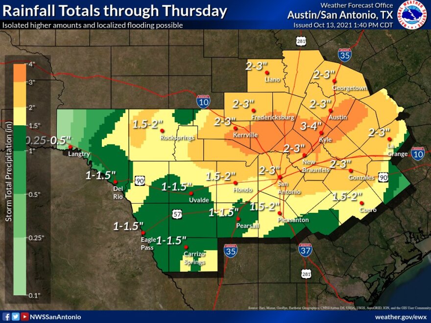
Residents of South Texas and the Hill Country will be first doused with rain and then chilled this week.
The National Weather Service reports the remnants of Hurricane Pamela are pushing up from Mexico on Wednesday and Thursday followed by the arrival of a cold front on Friday.
A flash flood watch has been posted for San Antonio and the Hill Country Wednesday evening.
930PM Radar Update: A line of showers and thunderstorms with heavy rainfall is approaching the I-35 corridor. Be alert for dangerous flash flooding developing over the next couple of hours. If you encounter a flooded roadway...Turn Around, Don't Drown! pic.twitter.com/cpmOXDNUAR
— NWS Austin/San Antonio (@NWSSanAntonio) October 14, 2021
National Weather Service Meteorologist Eric Platt said the rainfall totals will add up Wednesday evening and Thursday morning.
"During that time period, we're thinking along and west of the I-35 corridor rainfall amounts of 2 to 5 inches. Should be fairly wide spread across that area," he told TPR.
A Flash Flood Watch remains in effect until 7pm Thursday and now includes Bastrop, Caldwell, Guadalupe, and Wilson Counties. Thunderstorms are already developing across portions of Central TX and are expected to fill in over the Rio Grande Plains and move northwest tonight. #txwx pic.twitter.com/NUyjpHeRPD
— NWS Austin/San Antonio (@NWSSanAntonio) October 13, 2021
Platt said those higher isolated amounts would be in upper sections of the Texas Hill County that borders the Edwards Plateau.
Platt said even though both regions saw a dry end to summer and a fairly dry start to fall, heavy, sudden downpours can cause flash flooding. Low water crossings can especially become dangerous to cross.
The rain is expected to taper off early Thursday, and a cool front is expected to arrive the next day, producing milder, even chiller temperatures.
"We'll be seeing our highs on Saturday and Sunday back down into the 70s, low 70s that is for Saturday and Sunday, and mornings will be quite cool and quite pleasant if you like mid-40s and lower 50s," Platt said.
Those mid-40s are reserved for some sections of the Hill Country.
Gusty winds up to 20 and 25 miles per hour out of the southeast are expected with the passage of the remnants of Hurricane Pamela through the San Antonio area.
The arrival of the cold front on Friday will cause winds to shift out of the north and northeast with occasional gusts up to 25 miles per hour.


