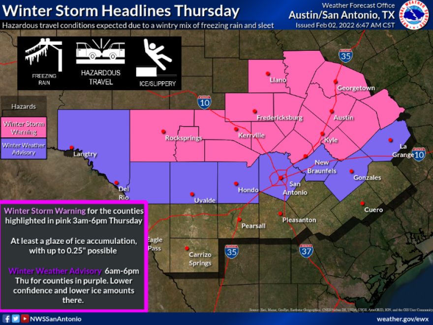
The National Weather Service has pushed the line for potential icing on freeways caused by an arctic cold front further south into Bexar County.
Accumulations of one-tenth of an inch are possible, especially in northern Bexar County. Comal County was also moved into the Winter Storm Warning area on Wednesday morning, where up to a quarter of inch of ice could stick to roads.
A winter weather advisory remains in effect Thursday for all of Bexar County.
The front, which began passing through Wednesday, will bring potential icing and wind chills as low the single digits by Thursday morning. The best chance of seeing freezing rain and sleet will be during the morning and early afternoon hours in San Antonio.
National Weather Service Meteorologist Andrew Quigley said residents in San Antonio and across the Hill County will need to bundle up, but that this is no winter blitz like February 2021 when widespread power and water outages lasted for days a time in some spots.

"You're going to want to be layering up, protecting your bare skin when you're going outside Thursday and Friday, but from a standpoint of severity that we saw last February this is going to come nowhere near that," he said.
The weather service did report some parts of the Hill Country could see up to 60 hours of freezing air temperatures, while San Antonio could see around 30 hours, so steps should be taken to insulate exterior pipes, bring in pets and cover plants that can't be moved inside.
Quigley said this arctic could front is like the typical one or two events South Central Texas can expect most winters.
"The anxiety is obviously understood given how extreme last February's event was, but again, last February was a very rare event. You're talking a once-in-30-or-40-years event," he said.
The Texas Department of Transportation has been treating area roadways for days leading up to the arrival of possible frozen precipitation, but the biggest concerns are to the north of the city.
"It's usually the Hill County, the northern part of our district, our San Antonio District, so Comal County, Kendall, Kerr County. Those are the areas that are affected the most," said Laura Lopez, a spokeswoman for the local TxDOT District.
Still, she said caution should be used by motorists in San Antonio.
"We have a lot of areas that are possibly going to freeze first," said Lopez about the city's many bridges, overpasses, cloverleafs and direct connectors.
She urged motorists to slow down on their approach to elevated roadways and be on the lookout for ice and give vehicles ahead plenty of distance.
Lopez also asked motorists to watch for state highway crews expected to be spraying brine on roadways to prevent icing.


