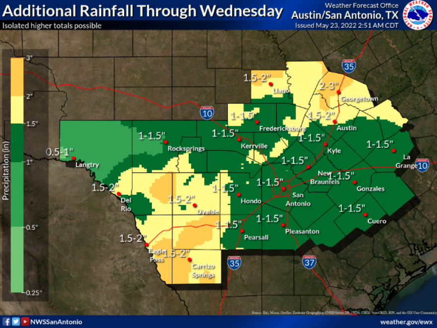
The National Weather Service reports there is a good chance of on-again, off-again showers through Wednesday as another cold front pushes into the area from the west.
The front will trigger showers in its advance and as it passes through San Antonio on Tuesday. Thunderstorms are expected to build to the west of San Antonio late Monday afternoon and Monday night and push to the east.
Showers return on Tuesday with daytime heating, forecasters said. Rain activity tapers off after Wednesday, but milder temperatures will stick around through Thursday. Highs in the 90s will follow on Friday and through the weekend.
Gusty winds, hail, and an isolated tornado cannot be ruled out, but forecasters said the overall risk of severe weather for San Antonio would be "slight" on Monday and "marginal" on Tuesday.
The weather service reports the best chances for rain are west of U.S. 281 on Monday afternoon and night and along and east of 281 on Tuesday.
If severe weather does break out, it will be more likely west of a Pleasanton to Austin line on Monday and north of a Fredericksburg to Austin line on Tuesday.
The weather service reports total rainfall through Wednesday will not be "drought-busting," but most of the San Antonio area should benefit from half-an-inch to 2 inches. Some isolated spots could see 3 to 4 inches.
Stage 2 water restrictions continue for San Antonio, so the area could definitely use some precipitation. Residents can only water their yards with automatic sprinklers once a week based on their street address. Washing and power washing driveways and sidewalks is forbidden, but residents can wash vehicles once a week at their homes, either on a Saturday or Sunday, but water runoff into the street is not allowed.
Private swimming pools must have 25% of their surface area covered with evaporation screens when not in use. Floating pool toys or decorations count as cover.
Outdoor commercial fountains can only be operated under a SAWS variance and hotels and motels have to notify guests that towel and linen changes are only done
by request to cut down on washing and save water.
Golf courses cannot irrigate between 10 a.m. and 8 p.m. and must have a water conservation plan approved by SAWS.
Drought conditions continue across Bexar County which has an outdoor burn ban in place through at least Fourth of July unless there is a dramatic improvement to fire prone conditions. Grass fires have charred several thousand acres in the area this spring.
Exceptional drought conditions persist west of San Antonio and for much of the Hill Country, north and northwest of the city.
The city has gotten off to a very dry start in 2022 and forecasters have said it is likely to continue through at least June. May is typically San Antonio's rainiest month of the year. The city usually receives nearly 4.5 inches in a May, but has only picked up around a third-of-an-inch at San Antonio International Airport so far this month, said Jason Runyen, a meteorologist with the National Weather Service in New Braunfels.


