The 2022 Atlantic hurricane season begins on June 1. Some scientists are warning that this year may be more active than average, with several powerful and devastating hurricanes. One of those scientists is Nick Shay, professor of ocean sciences at the University of Miami.
Below is an edited and condensed version of his conversation with TPR's Jerry Clayton.
Clayton: The predictions you're making for this year's hurricane season are based on something called the loop current. Can you explain what that is?
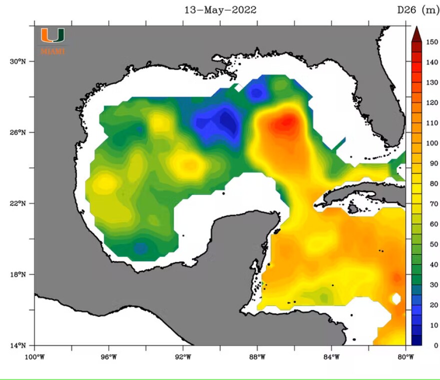
Shay: The loop current is a current that moves into the Gulf, largely through the Yucatan Straits. ... between Yucatan and Cuba. The strength of the current is typically about one and a half to two meters per second, very swift running current, and it has a cycle of about 6 to 11 months. The current goes relatively deep down several hundreds of meters. But what it really does is that it transports warm subtropical water coming out of the Caribbean into the Gulf of Mexico. And the reason that's significant is that the warm water has very high heat content in very warm temperatures.
Clayton: So you're saying that this loop current looks very similar to 2005 when we had Hurricane Katrina, correct?
Shay: That's correct. Recall that in the Gulf of Mexico (in 2005), we had the hurricane trifecta of three Category 5 storms in the Gulf and northwest Caribbean during that summer. And the way this year is shaping up, the pattern looks quite similar to 2005.
Clayton: So that means that the hurricanes have a potential for being stronger. Is that my understanding?
Shay: That's correct. The hurricanes could could get much stronger than they normally do, especially interacting with the loop current. And recall back in 2005 what happened after the second hurricane — that would be Rita. The loop current shed a big warm core eddy that moved west to southwest a few miles per hour. But in both cases, Rita and Katrina (grew) to Category 5 (strength) in that area.
Clayton: Now, aside from the loop current, La Niña and El Niño can have a real effect on the strength and number of hurricanes. What's happening with that this year?
Shay: We are in a La Niña environment right now, so a La Niña environment basically means for the Atlantic Basin, less shear in the atmosphere. Probably the steering currents will be a little bit weaker and perhaps even more moisture in the air. During El Niño, the opposite is true — you have more shear in the atmosphere, a little bit less moisture, and it has a negative effect on hurricane formation.
Clayton: To what extent do you believe climate change is driving these forces, and what is the effect on potential storms?
Shay: We know climate change is occurring. That's undeniable. The big question for us is, if it's occurring, how much more heat in the ocean is occurring over the various timescales? We are seeing incremental changes in the depth of the warm ocean features, and we're also seeing some increases in the heat itself. So whether that's climate change or global warming, it's unclear. But we know that it's happening. We just don't know what those exact numbers are.
NOAA's official prediction for the Atlantic hurricane season will be released on May 24th.


