On Monday, Sandy brought heavy rain, winds and storm surges to the Northeast, causing widespread flooding and extensive damage to hundreds of communities, particularly in New Jersey and New York.
But the drenching from all that water varied greatly by region.
In areas south of Atlantic City, N.J., where the storm made landfall Monday night, the wind was pushing out toward the ocean. This prevented high storm tides along the Virginia, Maryland and Delaware coasts and in Chesapeake Bay. But the same arm of the storm that held the ocean at bay carried a lot of rain.
Some parts of Maryland saw 12.5 inches of rain as Sandy passed through, according to the National Weather Service. That's nearly a quarter of Maryland's total rainfall in 2011 — about 51 inches — a large portion of which fell during Hurricane Irene. Delaware and New Jersey also recorded high rain lev els matching Irene's deluge.
All the rain Maryland got has to go somewhere: down. As it flows downhill, it takes soil and debris with it, and eventually fills creeks and rivers to the brimming point. A lot of this runoff will eventually end up in the Potomac River; the National Oceanic and Atmospheric Administration has issued a flood warning for the upper Potomac and a coastal flood warning for the river's tidal regions until Thursday.
Further north, New York saw relatively little rainfall — just 3.5 inches over the course of the storm. But off New York's coast, the swirling hurricane winds were pushing inland, piling water up against the shore. Combining with a high tide on Monday night, the storm surge broke records in New York and New Jersey.

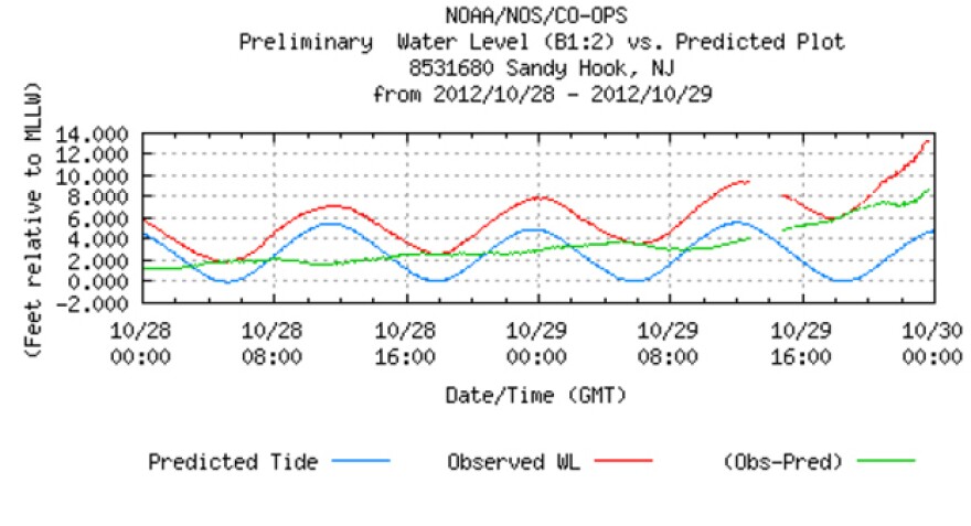
This tide map from Sandy Hook, N.J., shows the rising water as the storm approached.
The tide heights were impressive — 12.5 feet higher than normal at King's Point, N.Y., and 9 feet higher than normal in New Haven, Conn.
So were the waves. There were swells towering almost 40 feet off Atlantic City, and 30 feet outside New York Harbor. The combination of the storm surge, the tides and the waves resulted in the destructive flooding we now see.
Copyright 2020 NPR. To see more, visit https://www.npr.org. 9(MDAwMTM1NDgzMDEyMzg2MDcwMzJjODJiYQ004))

